BARKING TO UPMINSTER, THE DISTRICT LINE
What about “from Earls Court to Upminster”


BARKING (see chapter)

UPNEY
Why not using the London buses, as well?

EASTBURY MANOR
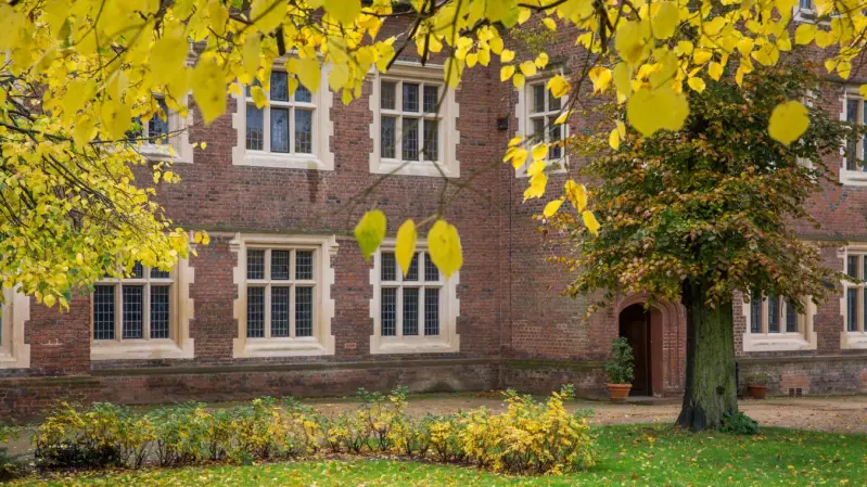
Built between 1560 and 1573 by Clement Sisley, Estburie Hall (as it was known then) is an Elizabethan Gentry House with a rich history and a remarkable story of survival. Retaining its Elizabethan Tudor exterior to this day, the house and its land have been inhabited by a long succession of owners, leaseholders and tenants.
MAYESBROOK PARK
Mayesbrook Park is a 43-hectare public park managed by the borough council. The southern end, which is mainly a large lake, is a Local Nature Reserve.The area covered by the park was once part of the historic Manor of Jenkins, seat of the Fanshawe family. For reasons which remain obscure, the park is nicknamed "Matchstick Island".
BECONTREE
BECONTREE HUNDRED
Becontree was an ancient hundred in the south west of the county of Essex. Its area has been entirely absorbed by the growth of London; with its name reused in 1921 for the large Becontree estate of the London County Council. Its former area now corresponds to the London Borough of Newham, the London Borough of Barking and Dagenham and parts of the London Borough of Waltham Forest and the London Borough of Redbridge. Its early extent also included parts of what is now the London Borough of Havering.
In 1831, the hundred occupied 35,950 acres (145.5 km2). In 1840 the hundred was included in the Metropolitan Police District by the Metropolitan Police Act 1839. The population of the hundred in 1851 was 46,777 and in 1861, 73,023. In 1887 the area is recorded as 37,705 acres (152.59 km2) and the population as 221,217.
The hundreds of England declined in administrative use because of the rise of various ad hocboards. By 1894 they were effectively replaced by a system of uniform local government districts, which were consolidated over time and finally replaced in 1965 by the London boroughs which are still in use.
The name is first recorded in the 1086 Domesday Book as Beuentreu, meaning tree of a man called Beohha. The original tree, at Becontree Heath, was the location that early hundred meetings took place. Before 1465 it included the area of Havering liberty, which comprised the parishes of Hornchurch, Romford and Havering-atte-Bower, and thus the hundred meeting place was not originally located on the fringe of the area. After the area of the liberty was removed, the hundred contained the parishes of Barking (including Great Ilford), Dagenham, East Ham, Leyton, Little Ilford, Walthamstow, Wanstead and West Ham.
PARSLOES PARK. The lake

Notes compiled by Gerald Lucy on Essex Field Club Website, transcribed literally from DAGENHAM AND DISTRICT HISTORY SOCIETY
In the early 1920s a small gravel pit existed on farmland north of the railway and east of Gale Street, just a short distance from Gale Street Farm which was on the south side of the line. The farm was demolished in 1926 for the building of Gale Street Halt (now Becontree Station) and the gravel pit was expanded to provide aggregate for the vast Becontree housing estate. During the pit’s working life it produced numerous Palaeolithic flint tools including 26 hand-axes, many of which are now in the British Museum.
This area is situated on the Taplow/Mucking terrace of the Thames and the gravel was laid down about 200,000 years ago (Marine Isotope Stages 8-6). Such a large number of hand¬axes in one spot indicates that this may have been the site of a camp used by Neanderthal hunters for butchering animals on the banks of the Thames.
The pit is now a large lake within Parsloes Park, a public park owned by the borough council.
THE BECONTREE ESTATE

The world’s greatest public housing project’ at its inception, Becontree is a gargantuan council estate covering four square miles of former fields, heath and parkland north of Dagenham.
The first houses were built on CHITTYS LANE, closer to CHADWELL HEATH, ELIZABETH LINE STATION


DAGENHAM HEATHWAY
DAGENHAM
Dagenham is centred 11 1⁄2 miles (19 kilometres) east of Charing Cross.
It was historically a rural parish in the Becontree Hundred of Essex, stretching from Hainault Forest in the north to the River Thames in the south. Dagenham remained mostly undeveloped until 1921, when the London County Council began construction of the large Becontree housing estate. The population significantly increased as people moved to the new housing in the early 20th century, with the parish of Dagenham becoming Dagenham Urban District in 1926 and the Municipal Borough of Dagenham in 1938. In 1965 Dagenham became part of Greater London when most of the historic parish become part of the London Borough of Barking and Dagenham.
Dagenham was chosen as a location for industrial activity and is perhaps most famous for being the location of the Ford Dagenham motor car plant where the Ford sewing machinists strike of 1968 took place. Following the decline of industry, the southern part of Dagenham adjacent to the River Thames forms part of the London Riverside section of the Thames Gateway redevelopment area, with a new district of Beam Park under construction on the former site of Ford Dagenham.
PARLOES PARK

Parsloes Park is a 58 hectare public park in Dagenham in the London Borough of Barking and Dagenham.[1] It is owned and managed by the borough council. A small area opposite the Wren Road entrance is managed for wildlife and designated as a Local Nature Reserve called Parsloes Park Squatts.[2]
The park derives its name from the Passelewe family, who owned the land in the thirteenth century. Paintings of the old manor house are held in the Valence House Museum.
The land was acquired by the London County Council in 1923. The park was opened by MP Christopher Addison on 13 July 1935, marking the official completion of the Becontree estate.
VALENCE HOUSE MUSEUM

DAGENHAM EAST
CIVIC CENTRE
grade II listed, 1930s art deco building designed by Ernest Berry Webber[2] and the former town hall of Dagenham Borough Council.
Becontree Heath functioned as the ancient meeting place for Becontree hundred, which covered much of what is now East London. In 1465, the hundred lost territory in the east and the meeting place became located on its fringe. When it was still a rural parish, Becontree Heath was a hamlet in Dagenham.

Beam Valley Country Park is a 74-hectare park in Dagenham in the London Borough of Barking and Dagenham.[1] Most of it is designated as a Local Nature Reserve (LNR) called Beam Valley,[2][3] but a narrow strip next to the River Beam south from Western Avenue is a separate LNR called Beam Valley (Environment Agency).[4][5] The park is also designated as two Sites of Borough Importance for Nature Conservation, Grade 1, one north and the other south of South Dagenham Road.[6][7][8]
The park was formerly derelict land. It has woodland and grassland, former gravel pits and the River Beam and Wantz Stream.[2] Birds found on the site include kingfishers, reed warblers, reed buntings and skylarks.[9] There is archaeological evidence that the site has been used since the Stone Age, and it also has a Roman pottery kiln.[1]
In 2014 Beam Valley Country Park was connected to Bretons Manor when a new pedestrian and cycling bridge was installed over the River Beam by Sustrans.[10]
- Nearest Train Station: Dagenham East Station
- Nearest Bus stop: 50m
- Bus Number: London Transport 103, 145
- Nearest Train Station: Dagenham East (District Line)
- If you are walking from here turn left, continue on to and walk across Reede Road, then use the crossing by the shops. The Chase can be accessed by taking the public footpath by the side of Ladbrokes the bookmakers.
- Nearest Bus stop: The Chase
- Bus Number: 174
- It can be boarded at Dagenham Heathway tube station on the district line or in Romford town centre.
The site of the chemical works, close to Dagenham East Station, is a major area of regeneration - where the Film Studios is emerging and set to provide many new forms of employment and opportunities for Dagenham residents and beyond.
OLD DAGENHAM
Dagenham is first mentioned in a charter of Barking Abbey dating from 687 AD. The first Dagenham was almost certainly just a small farmstead, the ham or farm of a man called Daecca.
For over 500 years after this the settlement was evidently too small to be mentioned in records.
Once the centre of Dagenham. The village was a busy area where farm workers and their families lived. There were several shops, 4 inns and a blacksmith's forge. Surrounding the village was countryside and farmland.
In 1205 Dagenham was large enough to have a chaplain and the Parish Church of St Peter and St Paulwas probably built at a similar time.
For centuries the church was central to the local community and most people went to church. The farm workers and their families would come here to pray for fair weather and good harvests. Here too they would meet and socialise with their friends. Even today the church contains clues about important people who have lived in Dagenham.
From the Medieval period until the 20th century Dagenham village did not alter its appearance much. The main street, called Crown Street ran east from the church and crossed the valley of the Wantz stream. After crossing the stream the road turned sharply south and became Bull Lane, ending in the Bull Public House.
William Ford's School was started as a result of money given by William Ford in 1825.
After 1921 the village was rapidly hemmed in on the north by the Becontree Estate. Much of the rural character was quickly lost. By the 1950s and 1960s many buildings that had been important landmarks in the village were in decay. In the late 1960s the majority of the village was demolished for social housing.
Today only the parish church, the Cross Keys public house and the Vicarage remain of the old village.
ST.PETER AND ST.PAUL CHURCH
St. Peter and St. Paul, known commonly as Dagenham Parish Church, is a Church of England parish church in the London Borough of Barking and Dagenham, England, formerly part of Essex. It is of medieval origin, largely rebuilt at the beginning of the nineteenth century.[
THE CROSS KEYS PH
A map of Dagenham Village from 1653 shows the 'Crossed Keys' in Church Street. The oldest parts of this building were constructed during the fifteenth century and it was restored by Charrington's Brewery in 1962. It was known as the Queen's Head for a period from 1700.
More regeneration: BEAM PARK

ELM PARK


As usual, an awesome post from HIDDEN LONDON

Look for the farms…
Elm Park is a suburban planned community in East London and part of the London Borough of Havering. Located 14.3 miles (23.0 km) east-northeast of Charing Cross, it is identified as a district centre in the London Plan with several streets of shops and a priority for regeneration. Prior to the construction of the extensive Elm Park Garden City development in the 1930s it was a scattered settlement of farms in the south of the parish of Hornchurch.
The place name Elm Park was devised in 1933.[2] It was derived from Elm Farm, which is first recorded in 1777 and was known as Elms in 1883.[3]
Elm Park has been connected to central London by the electrified District line service since 1935 and the planned development of the area formed part of the interwar private housing boom that was interrupted by World War II. After the war Elm Park expanded with social housing and it has formed part of Greater London since 1965.
Elm Park Garden City was a planned community by the developer Richard Costain and Sons Ltd., drawing on the ideas of the garden city movement. Costain purchased the land of Wyebridge, Elm and Uphavering farms for the development in 1933. Plans were announced for 7,000 houses on 600 acres (2.4 km2) of land for private sale in May 1933, and were submitted to Hornchurch Urban District Council in June. Costain negotiated a higher density of development than was usually permitted. In return the council achieved some improvements, including provision of wider roads, a bridge over the railway line, and the donation of land for Harrow Lodge Park. Costain built an estate office at the corner of Coronation Drive and Maylands Avenue that later became occupied by a real estate solicitor.[2]

An interesting post from LONDONTOPIA
LU STATION

The station is of similar design to Dagenham Heathway and Upney, but the station canopy is supported by one central pillar and the ramp to the ticket hall is much wider. The platforms are arranged on an island layout with station buildings typical of the 1930s. A long sloping walkway connects the platforms with the ticket hall which is on a road bridge over the line and above general street level.
Harrow Lodge Park is a large public park in Hornchurch in the London Borough of Havering. It was created by Hornchurch Urban District Council, partly on land donated by Richard Costain and Sons Ltd., the developers of Elm Park Garden City housing development.[1] It includes the cricket pitch used by Hornchurch Cricket Club.
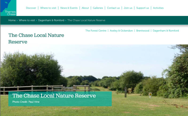
THE CHASE NATURE RESERVE
The Chase is a nature reserve in Dagenham in London. Most of it is in the London Borough of Barking and Dagenham, with a small part in Havering. It is owned by the boroughs, and managed by London Borough of Barking & Dagenham - Parks & Countryside Ranger Service.[1][2] The boroughs have designated the sections in their respective boroughs as Local Nature Reserves.[3][4] The Chase, together with the neighbouring Eastbrookend Country Park, is also designated a Site of Metropolitan Importance for Nature Conservation.[5]
BEAM VALLEY COUNTRY PARK
The Chase is a nature reserve in Dagenham in London. Most of it is in the London Borough of Barking and Dagenham, with a small part in Havering. It is owned by the boroughs, and managed by London Borough of Barking & Dagenham - Parks & Countryside Ranger Service.[1][2] The boroughs have designated the sections in their respective boroughs as Local Nature Reserves.[3][4] The Chase, together with the neighbouring Eastbrookend Country Park, is also designated a Site of Metropolitan Importance for Nature Conservation.[5]
BRETONS MANOR
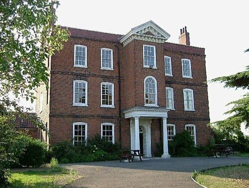
The manor, located adjacent to the River Beam in the parish of Hornchurch, is believed to have been named after the Breton family, who lived there from the 12th century.
The surviving building is a historic manor house that was rebuilt around 1740 with some features retained from an earlier building.
BRETONS OUTDOOR CENTRE

Enjoy the whole of the THAMES SIDE run places and its web!
HORNCHURCH (See chapter)

UPMINSTER BRIDGE (see chapter)
LU STATION

1930s style
UPMINSTER
I hope you are enjoying this guide
Why not donating?
THE NATIONAL TRUST