SOUTH of HORNCHURCH: COUNTRY PARK and MARSHES

SITE OF A RAF AIRFIELD… now HORNCHURCH COUNTRY PARK
Bus routes 252 and 652

Royal Air Force Hornchurch, is a former Royal Air Force sector station. The airfield was known as Sutton's Farm during the First World War, when it occupied 90 acres (360,000 m2) of the farm of the same name. It was used for the protection of London, being 14 miles (22.5 km) east north-east of Charing Cross.
Although the airfield closed shortly after the end of the war, the land was requisitioned in 1923 because of the expansion of the Royal Air Force and it re-opened as a much larger fighter station in 1928. The airfield was ideal to cover both London and the Thames corridor from German air attacks. It was a key air force installation between both wars and into the jet age, closing in 1962.
HERITAGE CENTRE

The RAF Hornchurch Heritage Centre was opened in June 2021 by the Hornchurch Aerodrome Historical Trust.[17] It opened in Suttons House on Suttons Lane, on the grounds of the former Suttons Institution, later St Georges Hospital.[18] The hospital was commandeered by the Air Ministry for use by RAF personnel during the Second World War. An official opening event was held on 23 September 2021.The RAF Hornchurch Heritage Centre was opened in June 2021 by the Hornchurch Aerodrome Historical Trust.[17] It opened in Suttons House on Suttons Lane, on the grounds of the former Suttons Institution, later St Georges Hospital.[18] The hospital was commandeered by the Air Ministry for use by RAF personnel during the Second World War. An official opening event was held on 23 September 2021.
PURFLEET HERITAGE AND MILITARY CENTRE

Conservation area

The former Officers' Mess is now a medical centre in Astra Close. The Officers' Mess (Astra House), Officers' Quarters (Astra Court East, West & North) and WO Quarters (89–99 (odd numbers) Wood Lane) are included in the RAF Hornchurch Conservation Area.


More reminders, inside the park
A number of pillboxes, command bunkers and gun positions, together with the largest number of surviving Tett Turrets in England, still exist within the boundaries of the former airfield and can be seen on the Eastern edge of the country park.


Not Anderson Shelters here, but…

There are three unusual and fascinating structures near what was once RAF Hornchurch. The first two were probably built by RAF personnel to protect officers and their families who lived in big houses near the aerodrome.
Spitfires and an American pilot (but, was he no part of the The Eagle Squadrons?)
A local school, The R. J. Mitchell School, was named after the man who designed the Spitfire, and a large monument to this effect, with wreaths placed on Remembrance Day, is within the school railings. Another local school (Suttons School) was renamed Sanders Draper School in 1973, after an American pilot, Flying Officer Raimund (Smudge) Sanders Draper, flying with the Royal Air Force at the time, had an engine failure on take-off and stayed at his controls to ensure his aircraft didn't crash on the building, which was full of children at the time
Farm, airfield, rubbish dump, council estate, park
Following a period of gravel extraction and infilling with rubbish in the 1970s, the airfield was extensively landscaped to create Hornchurch Country Park, with work commencing in 1980. Most of the former administrative and technical areas, including the two Type-A and one Type-C hangars, were levelled in the 1960s and the area is now a housing estate. The names of the streets of the estate commemorate the airfield and its pilots.
Airfield Estate

Airfield Way

PARK

A designated Local Nature Reserve, the park is an integral part of the Ingrebourne Valley which is rich in wildlife and has good opportunities for bird watching. The marshes (containing the largest freshwater reed bed in London) is a Site of Special Scientific Interest. The park has open areas of grassland for informal recreation and a lake which can be used for fishing.
The play area includes a model Spitfire which is used as climbing equipment. For those visitors who wish to exercise then there is an outdoor gym and ‘trim-trail’ which extends throughout the park.
Hornchurch Country Park directly joins several other local green spaces - Ingrebourne Hill, Berwick Woods, Berwick Glades and the Hacton/Gaynes Parkway.
INGREBOURNE VALLEY NATURE DISCOVERY CENTRE

Essex Wildlife Trust's Ingrebourne Valley Nature Discovery Centre is a partnership project between Essex Wildlife Trust and Havering Council. Built in Hornchurch Country Park, the centre overlooks the fantastic marshland and reedbeds of the River Ingrebourne Valley.
Cycling

This charming ride follows the Ingrebourne Valley, mostly along London Loop
Section 23. The route passes through Hornchurch Country Park - at various times a farm, military airfeld, gravel quarry and rubbish tip - until in 1980 the local authority acquired and transformed it into a wildlife haven.
You can continue along the London
Loop to Rainham Village and Rail Station, but this route includes busy roads.
The history behind the name of Havering’s River INGREBOURNE

By By Prof Ged Martin, Professor Of History At Galway University, Ireland
RAINHAM

Several London bus routes serve Rainham, including routes 103, 165, 287, 372, which provide connections to
Barking,
Elm Park,
Lakeside

Trains from FENCHURCH ST.STA, City of London

As always HIDDEN LONDON offers a good description of the district

A walk through the hidden history of local trading and commerce.
Created by artists Elaine Tribley and Amanda Westbury
Rainham is one of the most historic areas in Havering, if not the whole country. Not only does it have its roots going back to the Saxon period, there is strong evidence of a settlement before that with a Neolithic (or the new Stone Age dating back some 4,000-2,500 BC) site discovered west of LAUNDERS LANE in 1963. There are also remains of a Neolithic forest close to the mouth of the MARDYKE RIVER in Rainham Marshes.
An Anglo/Saxon burial ground from the 6th and 7th Centuries was discovered during excavations at GERPINS LANE PIT in 1930. A precious collections of objects such as swords, brooches, rings, spear heads and a pair of drinking horns were unearthed, as well as indications of earlier burials.
The original drinking horns are in the British Museum, but there is an exact copy on display in the Rainham Case in the HAVERING Museum. Today the burial site is under the Gerpins Lane Tip.
A hoard of 453 late bronze-age (900 to 800 BC) artefacts was found in Rainham in 2018. Known as the Havering hoard, it comprises swords, socketed axe heads, spear heads, knives, daggers, woodwork tools, bracelets, ingots, and other items, weighing more than 45 kg in total
Rainham is recorded in the Domesday Book of 1086 as Raineham, a settlement or village of Regna. Or, perhaps, the etymology follows that of Rainham, Kent which is thought to derive 'home of the Roegingas'. This is also of uncertain meaning, but could refer to 'the ruling people'. The link with Rainham in Kent is strengthened by the discovery of Jutish cemeteries in Rainham.
A myriad if contrasts: a village, a hub of industry, marshlands…
A place of trade, abundant with rumours of river-linked smuggling!.
In the 16th century industry was limited to a boat-builder and tannery. There are links between Rainham farms and the City of London from the Middle Ages and after the wharf was redeveloped in the 1720s trade increased; including the bringing of muck from London for use in the fields. By 1929 most of the farmland had been given over to market gardening.[10] The ferry to London was supplemented with new coaching links in the 18th century and a railway station opened in 1854. A second wharf was constructed in 1872 and from 1869 there was a growth in industrial development, including chemical and fertiliser factories.[10]The Murex iron-founders moved to Rainham in 1917 and grew along the river, eventually becoming part of the British Oxygen Company. Away from the river, other industries included brickmaking and after World War II there was a growth in gravel extraction.
Rainham is 13.6 miles (21.9 km) east of Charing Cross and is surrounded by a residential area, which has grown from the historic village, to the north and a commercial area, fronting the River Thames, to the south.
The economic history of Rainham is underpinned by a shift from agriculture to industry and manufacture and is now in a period of regeneration, coming within the London Riverside section of the Thames Gateway redevelopment area.
Walk

The suggested walk is inspired in the leaflet published by the LONDON BOROUGH OF HAVERING - DISCOVERING HAVERING. It starts in BRIDGE ROAD, where buses stop.
Conservation area

LA SALETTE SCHOOL

Creekside, Wharf, Rainham Creek

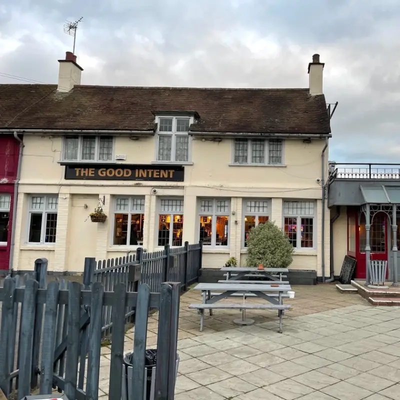
THE BELL PH

It has retained its Victorian appearance, complete with sash windows. In the 17th city owner bequeathed the land on which it stands to the ST.GILES-IN-THE-FIELDS CHARITY, ensuring the continued support fort the ALMSHOUSES near DRURY LANE, in COVENT GARDEN.
K2 PHONE
Creekside
The route to the former wharf that served the boats and their supplies
THE ANGEL INN PH


Rebuilt in 1907
REDBERRY HOUSE


18th house associated with the wharf and commercial area behind it. It has an exterior of 1800 and a ground floor room used as a counting-house.
The front door has steps, a circular cast-iron knocker, lion's-head blocks, a fanlight and a hood.
There are Insurance marks – 2 Sun, 1 Phoenix and 1 Royal Exchange.
A rear oriel window looks out over a yard with 19th coach house and stables. The carriage way at the side retains its stone and granite set paving.
JOHN HARLE may have had an office there.
A guest house
RAINHAM WHARF
Used from local stock since the 13th c., goods and passengers were being brought from London. Bought by HARLE, who imported building materials and coal
Group of buildings

Cobbles: original route for stagecoaches
VICARAGE


The original vicarage had probably disappeared by the mid 17th c, ant it had to be rebuilt.
1710 (article by H F Biden in the Upper Norwood Athenaeum 1913). Two storeys
and attic. Three sashes, no glazing bars, and 3 blank panels. Door off-centre
with wide hood on bold shaped brackets. Modern tiled roof. Three gabled
sash dormers. Gable ends. Plain stacks. Later wing to the rear with roof-ridge
rising above that of the main range. Two storey weatherboarded extension
at south-east with lower roof line, pantiled.
Now a private residence
WAR MEMORIAL


Unveiled in 1921, originally to commemorate those who lost their lives during WW I, but now it includes those that were lost during WW II and civilian casualties.
The site was known as THE GREEN.
It is constructed of red Belgian brick, with Portland stone dressings. Portland stone is a limestone quarried on the Isle of Portland, Dorset, England. There is cast stone ornamentation as well. The memorial is a hexagonal short tower with clock faces on three of its sides. On a sloping base, the names of the war dead are inscribed.
Broadway and Upminster Road
Businesses, shops and eateries


ST.HELEN & ST.GILES CHURCH


The Church of St. Helen & St. Giles is a Grade I listed building of high historical and architectural importance. It was built around 1170AD by Richard de Lucy, and despite some alterations, stands as it was built, with chancel, nave, aisles and tower. It is dedicated to St. Helen, or Helena (c. 247–327AD) who was reputedly British and by her marriage to a Roman Officer became the mother of Constantine the Great; and St. Giles (c.7th century), who was Greek. Such a dedication is unique in the British Isles.
Up to 1327AD it was administered by the Abbot of Lesnes Abbey; the vicars since then are listed to the right of the church door. There is much to be observed, but two features are unique and cannot be matched in any other church in the country; the beautiful arrangement of the six small windows in the east wall of the chancel, and the eye-like shaping of the six clerestory windows.
The walls are built of septaria, a rocklike substance eroded from the clay cliffs of the Essex coast, and flint-rubble, with limestone dressings. Clunch, a hard chalk, is included in the interior work, thus most of the building materials are local. All of the east windows were bricked up for 150 years before the 1897-1910 restoration. They now follow the Norman pattern. The Norman chancel arch is one of the best preserved examples of its kind
Note the doorway and the roodloft stairs which originally gave acess to a parapet of the rood loft on which images would have been displayed. The graffito in the staircase wall of a cog, or two-masted sailing vessel is interesting. This was probably pre-Reformation.
There are three 17th century bells in the tower, which are no longer able to be rung due to their supports being too decayed.
RAINHAM HALL


Here you have a extract of the NATIONAL TRUST website:
Rainham Hall is a rare survivor and a remarkably fine example of Queen Anne style architecture, built in 1729. It was designed as a home, for a merchant, to be lived in and used. Nearly 50 different families and inhabitants have resided at Rainham Hall since then, including solicitors, artists, children in a day nursery, a cycling vicar and architectural historians.
Rainham Hall was built in 1729 for sea merchant, Captain John Harle (1688-1742). John Harle was from a northern coal and shipping family who, after many years on the seas trading with various countries, settled in London, and built up an considerable import business, here, in RAINHAM.
In 1719, John Harle married Mary Tibbington, a widow. Sometime in 1739, Mary died childless. John remarried quite soon afterwards, to Sarah Gregory, a widow who lived in Rainham. In 1740 Sarah gave birth to their only child, also named John.
We don’t know who designed and built Rainham Hall, nor how much it cost. Only a lead rainwater hopper tells us it was built in 1729.
Some time ago, when at a car boot sale, a Rainham resident made an extraordinary connection with a dealer who sourced an original copy of John Harle’s will. She generously donated it to Rainham Hall in 2014. It has been conserved and exhibited as part of displays to the public. An electronic copy of the will is available via the National Archives website.
The wrought iron gates at the front have the initials of John HARLE and his wife Mary intertwined, and some have suggested that they are a work of JEAN TIJOU, the master blacksmith responsible for the ironwork at HAMPTON COURT PALACE.
In the gardens, an urn of some ten feet, from HARKE’s time. Victorian dog kennels. Traces of a 1920s herringbone path
Brick, 3 storeys, impressive wooden porch. Inside, a marble fireplace, wooden panelling, a carved wooden staircase, featuring the original trompe-l’oeil frescoes on the walls.
In some rooms DELFT tiles in the fireplaces indicate the wealth of the owner.
It recently appeared as a location in the 2019 BBC production of A Christmas Carol.
LODGE, COACH HOUSE and STABLES
A small 18th century house brick which was built before the main Hall. It might have been John Harle's first house here but more likely his business office and counting house. It is panelled throughout in softwood.
Coach house, a large plain building of stock brick with two round headed coach arches.
Stable yard. This is divided from the garden by ornamental ironwork. It is 18th in stock brick with round headed coach arches of red rubbed brick
Former LIBRARY

The existing Rainham Library in shop premises in Upminster Road South had long been recognised as inadequate. With the establishment of the London Borough of Havering in 1965 the call for a new library in Rainham was immediately on the agenda. A site in Bright’s Avenue, Rainham had been purchased for £6,450 by November 1965. However by January 1966 a local estate agent made an offer to the Council that they should acquire a building in Broadway, the former Stanton Radio Ltd premises, which had been built in the 1950s.
The Council were anxious to pursue this as it would ensure a new library for Rainham far quicker than building from scratch. The costs for converting the building were estimated at around £20,000 more than the expected charge for building on the Bright’s Avenue site…
Carry on reading the LAYERS OF LONDON web
THE PHOENIX PH

Rebuilt a few times in the 18th and 19th cs, it has certainly lived up to its name.
A posthouse in the 1820s, a telegraph office in the the 1870s.
COLD BLOODED. Reptiles on sale!

Some local pubs stories

Some interesting stories about local pub names

LIBRARY


Rainham Library project is a housing and community facility development for the London Borough of Havering joint venture with the Greater London Authorities.

FERRY LANE
In the late 19th c the THREE CROWNS HOTEL , on this road, became a resort for day trippers.

"More about RAINHAM’S lost pubs
RAILWAY STATION

The station was opened in 1854 on the original route of the London, Tilbury and Southend Railway from London to Tilbury, which was extended to Southend-on-Sea in 1856 and Shoeburyness in 1884. In 1888 a second, more direct, route to Southend was completed several miles to the north.
In 1891 the whole station was burnt down including the booking office and waiting rooms. Rebuilt in wood.


RAINHAM WHARF
To the MARSHES


The walk to the RSPB CENTRE takes around 1 hour

The Thames-side barge wharf at Rainham had been constructed following the Second World War using some of the floating roadway units that had returned from the Mulberry Harbour.
Site of the THREE CROWNS, now the MUSEUM OF GARDEN ESCAPES & THE BELVEDERE
The Belvedere’, a new covered seating area, is designed for the local community to enjoy the views over the river Thames, and the Museum of Garden Escapes provides a welcoming environment and place of interest for all visitors, whether on a lunch break from work, dog walking, or cycling/walking the RSPB Rainham Marshes route between Rainham and Purfleet.
The Museum of Garden Escapes is located on the historic footprint of the Three Crowns Inn site.
These new amenities have been designed by the London Riverside BID to meet local demand from the area’s workforce for usable outdoor spaces.
RAINHAM MARSHES


Stretching to the banks of the River Thames, Rainham Marshes remain one of the few ancient marshlands in London, and hold the key to the area's thriving industrial history.
In the late 19th and early 20th centuries the area enjoyed a boom in the increase of manufacturing companies along the riverside including Daldy & Co, the coal and timber merchants; Phoenix Timber, and Murex, iron-founders and ferroalloy manufacturers, whilst the marshes were used as a military firing range. Following the acquisition of the land by the RSPB in the year 2000, the area has been developed into a nature reserve and is home to an array of wildlife, from water voles to dragonflies, and birds of prey such as the peregrine falcon.
Not a nature reserve…
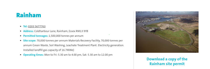


The marshes to the west of the nature reserve have been used as a landfill site for rubbish from London and the local area. Rainham Landfill is operated by Veolia ES Landfill Limited.[19] The site occupies an area of 177 hectares, and accepts up to 1,500,000 tonnes per year. This includes up to 70,000 tonnes per year in a Materials recovery facility and 70,000 tonnes per year of Green Waste.[19] There are facilities for soil washing and a Leachate Treatment Plant. The decomposition of organic matter within the landfill generates a gas containing up to about 50 percent methane. This landfill gas is collected by a network of pipes and since 2001 has been used in an onsite power station. The station is owned and operated by EDL. The plant comprises eight 1.25 MW, three 1.4 MW, two 1.1 MW and one 1.0 MW reciprocating engines which drive electricity generating sets.[20] The electricity produced is fed into the National Grid. The station has a generating capacity of 17.8 MW and typically generates 95 GWh of electricity per year. This is equivalent to powering 14,600 homes. The site is expected to produce landfill gas for electricity generation to beyond 2030.
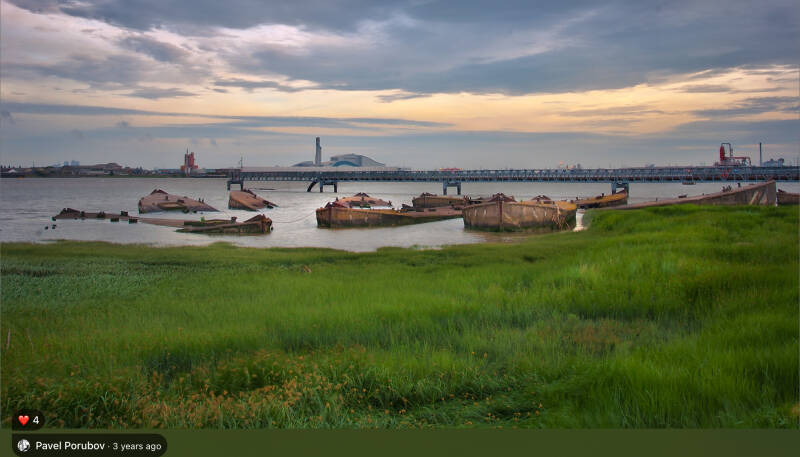
THE CONCRETE BARGES OF RAINHAM MARSHES


Why not donating?
